Malaysia Airlines Flight 370 Google Maps – The Buzz Explained
The internet has reignited interest in one of aviation’s most baffling disappearances: Malaysia Airlines Flight 370. But this time, the conversation isn’t led by official investigations or press releases—it’s coming from Google Maps.
Searches for “Malaysia Airlines Flight 370 Google Maps” are climbing fast, and TikTok videos, Reddit posts, and YouTube deep dives are claiming users have spotted the missing plane through satellite imagery. The idea sounds wild—but is there anything to it?
Read also: HopTraveler.com Review
What Happened to Malaysia Airlines Flight 370?
Flight MH370 vanished on March 8, 2014, during a routine journey from Kuala Lumpur to Beijing. The aircraft, a Boeing 777 carrying 239 passengers, lost contact with air traffic control less than an hour after takeoff. Despite years of search missions and parts of the plane washing up in the Indian Ocean, the wreckage itself has never been found.
Theories have ranged from mechanical issues to deliberate sabotage. But the lack of closure has led to endless speculation—and now, internet sleuthing.
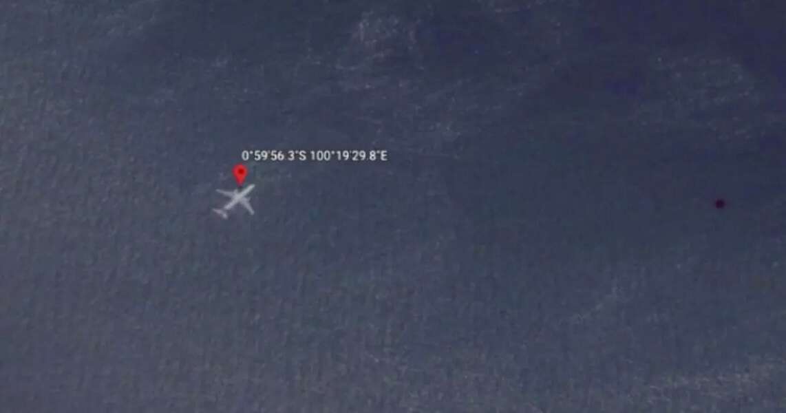
Why Is Google Maps Involved?
In recent months, the term “Malaysia Airlines Flight 370 Google Maps” began trending due to viral content showing coordinates where users believe the plane might be visible. These screenshots show what look like aircraft-shaped figures under the ocean surface or hidden in forested regions.
Popular posts have pointed to:
- Underwater shapes in the South Indian Ocean
- Aircraft-like forms in Cambodian jungle terrain
- Odd outlines in unsearched areas around Southeast Asia
All of this is based on user-generated exploration—no official confirmation, no real-time satellite tracking, and no verified discoveries.
Are the Coordinates Real?
While the coordinates being shared online do exist, the legitimacy of the images is questionable. Google Maps and Google Earth rely on compiled satellite images, many of which are outdated or low resolution. What looks like a submerged airplane could be anything from coral reefs to digital glitches.
Experts in satellite imagery analysis have cautioned against trusting these viral claims. Satellite distortion, cloud shadows, and pareidolia (the brain’s tendency to see familiar shapes) are more likely explanations.
What Experts Are Saying
Aviation and satellite professionals agree: Google Maps is not a reliable source for tracking missing planes. Images may be outdated by years, and objects under the ocean can appear warped, faded, or misrepresented due to light and water depth.
While the curiosity is understandable, the reality is far less exciting—most of the images circulating online do not meet the standard of credible evidence.
Why the Keyword is Trending
The phrase “Malaysia Airlines Flight 370 Google Maps” is trending because:
- It taps into unresolved curiosity and digital mystery
- Google Maps gives anyone a chance to “investigate”
- Social media platforms amplify anything that appears visually strange
This is less about real leads and more about the internet’s obsession with solving mysteries.
Final Thoughts
The mystery of Malaysia Airlines Flight 370 continues to haunt the digital world. While Google Maps may not hold the answers, it has become a tool for online explorers and curious minds. The idea of finding MH370 with a zoom and a scroll is compelling—but until solid proof emerges, these viral sightings remain just that: speculation.